


On this page you can find:
- Accessible Map of the course
- Accessibilty guide and facilities information
- Vehicle pick up and drop off points at each village
- Walking directions from public transport to each starting village
- Course variations for wheelchair, mobility aid, or stroller/pram accessibility
- Bus stop locations with google map links for the free accessible shuttle buses
- Contact information
Accessibility at 7 Bridges Walk
We want everyone to feel welcome and supported at 7 Bridges Walk.
Our team have worked hard to make the course as accessible as possible so that everyone can finish and complete the course in their own way.
However, due to natural terrain in some areas, certain sections of the course may not be suitable for all mobility needs.
We recommend bringing a support person to help navigate any tricky spots.
Our team will be on hand throughout the day, to help answer any questions.
There will be plenty of signage and staff on the route.
You will find everything you need on this page, and if you have further quesions, please reach out to our team.
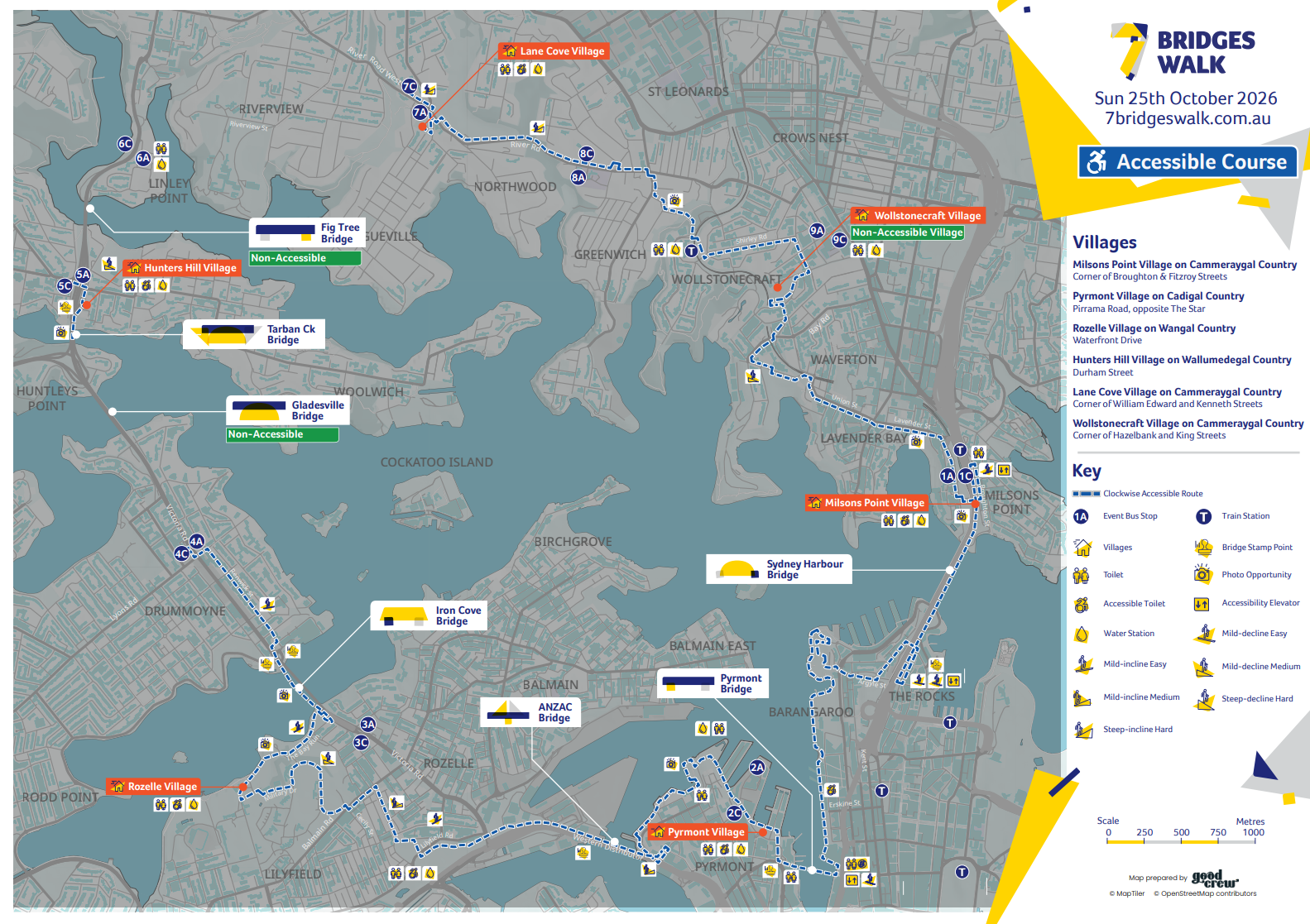
Click or tap on the map image to download.
Ways we support accessibility needs at the event
- Accessible Route Map and information
Download the Accessible Route Map to help plan your day and see specific information about inaccessible sections of the course. - Wheelchair Charging Stations
There will be wheelchair charging stations available at every village located at the first aid tents. Keep an eye out for the signs at each village or ask the friendly volunteers at the Cancer Council Information Tent. Please note, we will have standard power outlets available, if you have specific requirements, we recommend that you bring your own charging cables to ensure compatibility with your device. - Accessible Toilets
All villages have accessible toilets provided. Additionally, accessible toilets can be found on the course, located at:- 400 Barangaroo Ave, Barangaroo
- Rozelle Parklands, Rozelle
- Burns Bay Reserve, Riverview
- Event Buses
We have accessible event buses running all day starting from 8:30am. There will be multiple bus stops around the course, so you can walk as much of the course as you would like. - On-the-Day Assistance
Our team is here to help! If you need support or directions on the day, please visit the Cancer Council Information Tent at any village or ask a friendly volunteer/staff member on the course or at the bridges. Each of the villages also have dedicated lanes and check-in assistance for people who require extra support or assistance. - Bridge & Village stamps for Event Guide
- As some parts of the course aren’t accessible and will need to be accessed by the free event shuttle buses, we have made sure that we have stamps located at the next villages and bridges along the course, so you can get your Event Guide stamped for those locations.
-
- Lane Cove Village will have stamps for: Hunters Hill Village, Gladesville Bridge, Tarban Creek Bridge & Fig Tree Bridge
- Milsons Point Village will have a stamp for Wollstonecraft Village
Please just ask at the stamping tent for one of those stamps as you make your way into the villages outlined above.
Don’t forget, we also have our digital stamps, so you can open your dashboard and digitally stamp those locations along the way!

Vehicle drop off and pick up zones at each village
|
VILLAGE |
LOCATION |
|
Wollstonecraft Village |
|
|
Rozelle Village |
Intersection of Wharf Rd & Military Dr within Callan Park, at road closure point |
|
Pyrmont Village |
Within the access Road to Sydney Wharf Marina (located off of Pirrama Rd) |
|
Milsons Point Village |
Fitzroy Street, Milsons Point – at the top entry to Bradfield Park, near the pedestrian crossing. |
|
Hunters Hill Village |
No suitable location |
|
Lane Cove Village |
Central Park Access Driveway on Kenneth St (before Bus Stop) |
Walking directions from public transport to each starting village
Follow these direction in reverse order to get home
Milsons Point Village
Milsons Point Village - link to maps
Milsons Point Village is located in Bradfield Park, Milsons Point.
Train: The closest train station is Milsons Point Train Station on the T1 North Shore Line. From there it is a 5-minute walk down Alfred Street South to the Bradfield Park.
Bus: The closest bus stop is Alfred St at Lavender St, only a 2-minute walk to Bradfield Park.
Ferry: Milsons Point Wharf and Jeffrey Street Wharf are both approximately 10-minute walk to Bradfield Park.
Pyrmont Village
Pyrmont Village - link to maps
Pyrmont Village is located in Pyrmont Bay Park, Pyrmont.
Light Rail: Pyrmont Bay Light Rail Station is a 3-minute walk to Pyrmont Bay Park.Bus:The closest bus stop is Pirrama Road, opposite The Star, which is a 3-minute walk to Pyrmont Bay Park.
Ferry: The F4 route serves Pyrmont Bay Wharf, which is a 4-minute walk to Pyrmont Bay Park.
Train:The closest train station is Town Hall which is 15-20-minute walk to Pyrmont Bay Park.
Hunters Hill Village
Hunters Hill Village - link to maps
Hunters Hill Village is located at 1st Hunters Hill Scouts Hall (Windeyer Hall), Durham Street, Hunters Hill.
Bus: The closest bus stop is Gladesville Road at Howard Place which is approximately 5–7-minute walk to Hunters Hill Village.
Ferry: The F3 Parramatta River Ferry serves Huntleys Point Wharf, which is a 15-minute walk to Hunters Hill Village.
Rozelle Village
Rozelle Village - link to maps
Rozelle Village is located in Callan Park, Rozelle.
Light Rail: Lilyfield Station is a 10-minute walk to Callan Park.
Bus:There are several bus stops located nearby Callan Park on the northern edge of the park (along Balmain Road) and on the southern edge of the park (along Victoria Road).
Lane Cove Village
Lane Cove Village - link to maps
Lane Cove Village is located at Central Park, Longueville.
Bus: The closest bus stop is near Kenneth Street and takes approximately 3-5 minutes to walk to Central Park.
Train: Take the T1 North Shore Line to Chatswood or St Leonards Station, then transfer to a bus heading to Longueville.
Wollstonecraft Village
Wollstonecraft Village - link to maps
Wollstonecraft Village is located at Brennan Park.
Train: Take the T1 North Shore Line to Wollstonecraft Station, from there it’s approximately 5-minute walk to Brennan Park, via Shirley Road and Hazelbank Road.
Bus: The closest bus stops are located on Pacific Highway or Shirley Road, which are a short walk to Brennan Park.
Planning ahead for wheelchairs, mobility aids and strollers
12 sections of the course to consider that have varied accessibility or no accessible path
This information is provided to help participants understand where challenges may arise on the day to help you plan your day.
Please note that there is signage on the day as well as volunteers on the course to help support you with where to go.
General accessibility information
To help participants plan their walk, please consider the following accessibility information before commencing the course.
Step-Free Access
Sydney Harbour Bridge
- Step-free access onto the bridge is available via the Northern Side Elevator on Broughton Street.
- Step-free access off the bridge is available via the Southern Side Elevator, exiting onto Cumberland Street.
Pyrmont Bridge
- Step-free access is available via the lift located on the CBD/Cockle Bay Wharf side of the bridge, on the southern side of the escalators.
Steep Gradient Locations
The following sections of the course include moderate to significant inclines or declines that may present challenges for participants with limited mobility or those using wheelchairs, mobility scooters, walking aids, or other assistive wheeled devices:
- Quarry Master Drive & ANZAC Bridge Pedestrian Ramps: Significant incline.
- Denison Street: Significant incline.
- Renwick Street, Drummoyne: Moderate Incline
- River Road, Lane Cove: Two significant inclines and one significant decline.
- Glenview Street, Greenwich: Significant decline.
- Smoothey Park, Wollstonecraft: Significant incline.
- Wollstonecraft Train Station: Moderate Incline
- Morton Street, Wollstonecraft: Moderate incline.
- Crows Nest Road, Waverton: Moderate Decline
- Woolcott Street: Moderate decline.
- Union Street, McMahons Point: Moderate Incline
Participant Advice
Participants are encouraged to review the course map and accessibility notes before event day to determine the route that best suits their individual needs. Where possible, allow additional time to navigate steeper sections and consider walking with a companion if assistance may be required. Event staff and volunteers will be positioned throughout the course and are available to provide support where practical.
Course accessibility
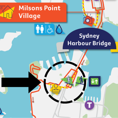
1. Sydney Harbour Bridge – limited accessibility
11 Cumberland Street, Sydney
To gain access onto Sydney Harbour Bridge, use the Northen Side Elevator, located on Broughton Street.
After crossing the Sydney Harbour Bridge, participants requiring step-free access should use the Southern Side Elevator to exit onto Cumberland Street.
The main course route continues through the tunnel under the bridge, but this section includes stairs and a steep ramp that are unsuitable for wheelchairs or mobility aids.
From Cumberland Street:
- Turn right (south) towards the event Volunteers where the Sydney Harbour Bridge Stamp can be given
- Turn back around, facing north up Cumberland Street, traveling back past the Southern Side Elevator
- Then turn left again at Lower Fort Street
- Follow Lower Fort Street to the end and turn right onto Argyle Street
- Rejoin the main course on Argyle Street
2. Pirrama Park – limited accessibility
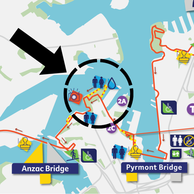
5010 Pirrama Road, Pyrmont
The main course follows the timber boardwalk at Pirrama Park, which extends over Sydney Harbour.
As the boardwalk is not suitable for wheelchairs, participants with accessibility needs are advised to continue along the concrete footpath via Pirrama Road.
This alternate path is fully accessible and approximately 400m shorter than the boardwalk section, allowing participants to re-join the main course smoothly.
3. Bowman Street & Bank Street, Pyrmont - limited accessibility
Bowman Street & Bank Street, Pyrmont
At the intersection of Bowman Street and Bank Street, the main course continues along the left-hand side of Bank Street. However, there are no accessible kerb ramps on this side of the road, making it unsuitable for participants using wheelchairs, mobility scooters, prams, or other mobility aids.
To ensure safe passage, participants should:
- Using the driveway access points; from Bowman Street cross over to the right-hand side of Bank Street.
- Continue along the right-hand side of Bank Street
- Using the driveway access point cross over Bank Street, and use the pedestrian access ramp on Quarry Master Drive
- Rejoin the course from Quarry Master Drive
Quarry Master Drive & ANZAC Bridge Pedestrian Ramps feature significant gradient incline that may present navigation challenges for individuals with limited mobility or those utilizing assistive wheeled devices.
Traffic controllers and course crew will be positioned at this location to provide guidance and assist participants requiring the accessible route.
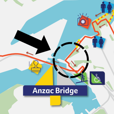
4. Denison Street & Alfred Street, Lilyfield - limited accessibility
Denison Street & Alfred Street, Lilyfield
At the intersection of Denison Street and Alfred Street, the main course turns left onto Cheltenham Street. This section has narrow footpaths with telegraph poles located within the pedestrian path, which may make it difficult for people using wheelchairs, mobility scooters, prams, or other mobility aids to pass safely without entering the roadway.
To ensure safe passage, participants should:
- Continue straight along Denison Street to Balmain Street
- Turn left onto Balmain Road
- Rejoin the course where Balmain Road meets Cecily Street
Denison Street features a significant gradient incline that may present navigation challenges for individuals with limited mobility or those utilizing assistive wheeled devices.
Course crew will be positioned at this location to provide guidance and ensure participants requiring accessible pathways are directed to the correct route.
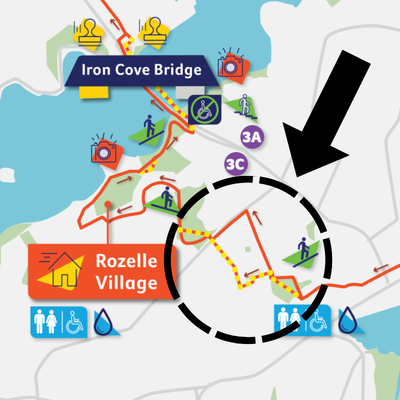
5. Callan Park, Lilyfield - limited accessibility
Callan Park, Park Drive & Cecily Street, Lilyfield
At the corner of Park Drive and Cecily Street, the main course route leads to a set of stairs that are not accessible for participants using wheelchairs or mobility aids.
To ensure safe passage, participants should:
- Turn left onto Park Drive (a vehicle and pedestrian shared path)
- Turn right onto North Crescent
- Rejoin the course from there
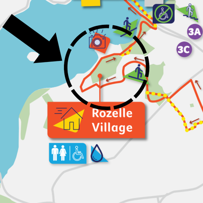
6. Iron Cove Bridge, Rozelle - limited accessibility
Iron Cove Bridge, 272 Victoria Road, Rozelle
At this section of the course, participants have two route options:
- Option 1 – Under Iron Cove Bridge: This route follows a concrete path beneath the bridge. It is not accessible due to steep gradients.
- Option 2 – Across Iron Cove Bridge (Victoria Road): This route follows the footpath along Victoria Road. It is fully accessible with a low-grade incline and is the recommended option for participants using mobility aids.
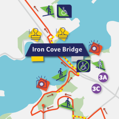
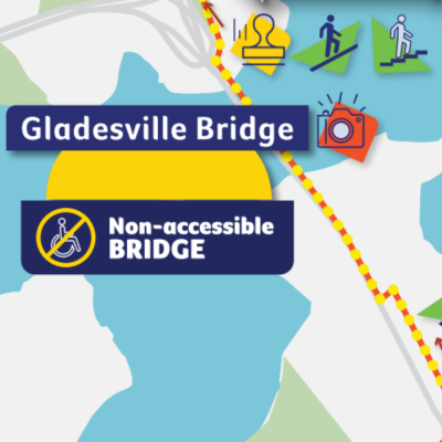
7. Gladesville Bridge, Drummoyne - not wheelchair or mobility aid accessible
Gladesville Bridge, Victoria Road, Drummoyne
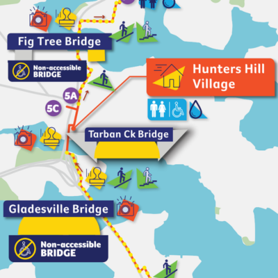
Gladesville Bridge is not accessible for participants using wheelchairs or mobility aids.
To bypass this section safely, participants can use the event shuttle bus service:
- Boarding Point: Bus Stop 4C - Victoria Road near Lyons Road
- Drop-off Point: Bus Stop 5C - Burns Bay Road, Hunters Hill
From there, participants can rejoin the course and continue toward Tarban Creek Bridge and Hunters Hill Village. Signage will be in place to assist participants with directions to and from the shuttle stops.
8. Hunters Hill Village to Lane Cove Village - not wheelchair or mobility aid accessible
Hunters Hill Village through to Lane Cove Village
This part of the course includes steep terrain, stairs and limited footpath access making it unsuitable for participants using wheelchairs or mobility aids.
To bypass this section safely, participants can use the event shuttle bus service:
- Boarding Point: Stop 5C – Burns Bay Road, Linley Point
- Drop-off Point: Stop 7C – River Road West, Blaxland’s Corner
From there, participants can rejoin the course and continue toward Lane Cove Village. Signage will be in place to assist participants with directions to and from the shuttle stops.
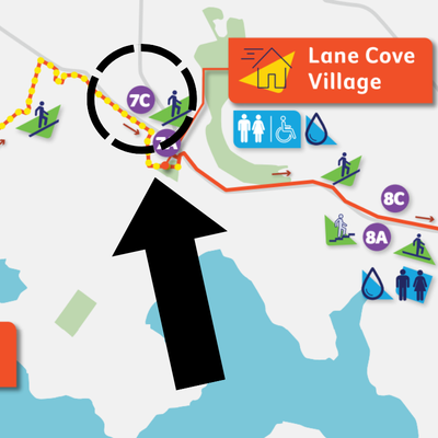
9. River Road West Bus Stop 7C, Longueville
There is no suitable point to cross River Road West at the 7C bus stop. Participants should continue along River Road West and cross over the pedestrian crossing at the traffic lights and turn left onto Kenneth Street into Lane Cove Village.
To remain on the accessible route, particpants should:
- After alighting the bus, turn right and continue along River Road West.
- Cross River Road West at the pedestrian crossing at the Longueville Road traffic lights.
- Cross Northwood Road at the same traffic lights.
- Turn left onto Kenneth Street and continue into Lane Cove Village.
- Rejoin the main course from Kenneth Street.
Signage will be positioned at this point to guide participants along this alternative route.
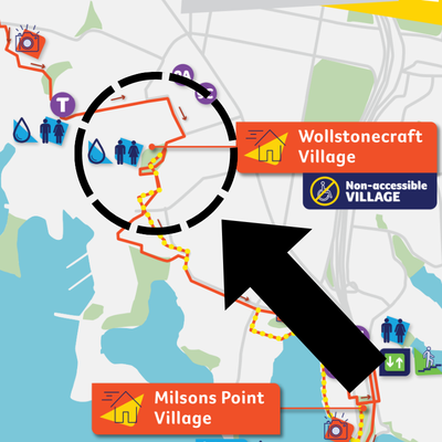
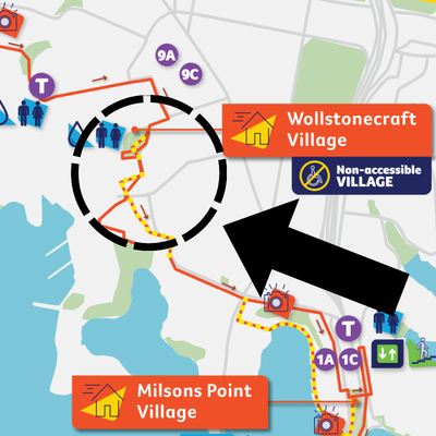
10. Brennan Park, Wollstonecraft - not wheelchair or mobility aid accessible
Brennan Park, Corner of Hazelbank Road and King Street, Wollstonecraft
Wollstonecraft Village is located on sloped and uneven ground, making it unsuitable for participants using wheelchairs or mobility aids.
To ensure a safe and accessible journey, participants are advised to bypass this village and continue directly along the main course. This adjustment will not impact the overall route or distance.
11. Carr Street & Crows Nest Road, Waverton - not wheelchair or mobility aid accessible
At the intersection of Carr Street and Crows Nest Road, the main course diverges from the accessible route due to stairs and uneven pathways, which are not suitable for participants using wheelchairs, mobility scooters, prams, or other mobility aids.
To remain on the accessible route, particpants should:
- Continue straight along Crows Nest Road
- Cross to the opposite side of the road at the pedestrian crossing at Bay Road
- Turn left onto Woolcott Street
- Continue along Woolcott Street until you reach Euroka Street
- Rejoin the main course at Euroka Street
Woolcott Street features a moderate gradient decline that may present navigation challenges for individuals with limited mobility or those utilizing assistive wheeled devices.
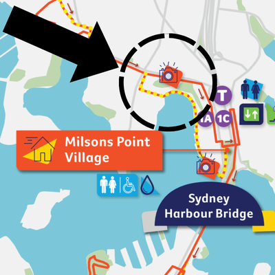
12. Corner of Union Street and Blues Point Road, McMahons Point - not wheelchair or mobility aid accessible
The standard course along Blues Point Road includes stairs, which are not accessible for wheelchair users or those with mobility aids.
To remain on the accessible route, particpants should:
- Continue straight on Lavender Street
- Turn right on Alfred Street South
- Follow Alfred Street South directly to Bradfield Park (Milsons Point Village) to rejoin the course

Bus stops to travel between villages and bridges
Going forward in the course direction.
Buses run every 30 mins from 8:30am until noon. From 12noon, buses will run every 10 minutes.
Click the Google Map links below on your device to navigate your way to these bus stop locations.
|
Bus Stop |
Suburb |
Bus stop address with Google Maps link |
|
Bus Stop 1C |
Alfred Street, Milsons Point |
|
|
Bus Stop 2C |
Pirrama Road, Pyrmont |
|
|
Bus Stop 3C |
Victoria Road, Rozelle |
|
|
Bus Stop 4C |
Victoria Road, Drummoyne |
Victoria Rd after Lyons Road, opposite the Drummoyne Post Office |
|
Bus Stop 5C |
Burns Bay Road, Hunters Hill |
At Gladesville Road, on the north bound exit ramp to Church Street |
|
Bus Stop 6C |
Burns Bay Road, Linley Point |
On western side of Burns Bay Road opposite intersection of View Street |
|
Bus Stop 7C |
River Road West, Lane Cove |
|
|
Bus Stop 8C |
River Road, Greenwich |
On northern side of River Road, opposite at Greenwich Primary School |
|
Bus Stop 9C |
Rocklands Rd, Wollstonecraft |
At Mater Hospital on Rocklands Road, opposite Sinclair Street |
Heading backwards through the course
If you need to travel in the opposite direction of the course, there are buses every 30 mins at these stops.
|
Bus Stop |
Suburb |
Address with Google Maps link |
|
Bus Stop 1A |
Alfred street, Milsons Point |
Alfred Street South opposite side of the road to Milsons Point Train Station |
|
Bus Stop 2A |
Pirrama Road, Pyrmont |
|
|
Bus Stop 3A |
Victoria Road, Rozelle |
|
|
Bus Stop 4A |
Victoria Road, Drummoyne |
Victoria Road near Lyons Road, outside the Drummoyne Post Office |
|
Bus Stop 5A |
Burns Bay Road, Hunters Hill |
|
|
Bus Stop 6A |
Burns Bay Road, Linley Point |
|
|
Bus Stop 7A |
River Road West, Lane Cove |
On southern side of River Road West, near William Edward Street |
|
Bus Stop 8A |
River Road, Greenwich |
|
|
Bus Stop 9A |
Rocklands Road, Wollstonecraft |

Questions and support
Accessibility information
Please reach out to our logistics team with course accessibility questions ONLY - thank you!
General event or website questions
Reach out to our support team with any questions via phone or email.
You might be interested in...

7 Bridges Legends
Find out how to join our 7 Bridges Legends VIP Club.

Plan your day
See the course map, village information, free buses, accessibility and more.


